
For the weekend around May 24th, we spent quite some time wondering where to go. The forecast for May 24th was unfavorable, and in the end, the group decided to cross Vitosha Mountain by ascending from the village of Zheleznitsa and descending towards Knyazhevo or Boyana. Out of the 12 people who set off, none had hiked this route or explored this part of Vitosha before. Most of us had only climbed Cherni Vrah from Aleko Hut.
We met at 8:30 a.m. in the center of Zheleznitsa village, where we left our cars. The plan was that after descending on the other side of the mountain, a friend would come by car to transport the drivers back to Zheleznitsa, and then they would return to pick up the rest of the group.
From the village center, we followed the marked trail along the river and gradually began climbing the mountain slope. Right at the beginning, we made a “mistake” — I put that in quotation marks because it was not exactly a mistake, but... My intention was to pass by the Sinyata Strela Shelter and thus cover more peaks. However, as I already mentioned, nobody in the group had been to this part of the mountain before, so we missed the turnoff and were climbing toward Kupena Hut when we realized we had gone slightly off route.
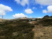
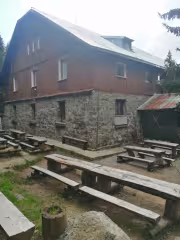
The trail to Kupena Hut is clear and wide, making it almost impossible to get lost. The route from the hut to Cherni Vrah is also very well marked, with trail markers every 20 meters. After a short break in front of the hut, which appeared to be closed, we decided to leave the standard trail and make a detour to Kupena Peak (I do not mean Golyam Kupen Peak, which is directly above the hut).

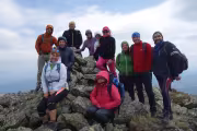
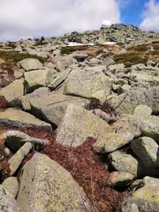
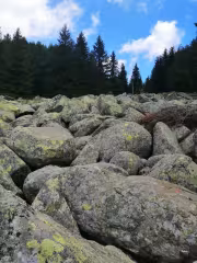
After leaving the main trail, we initially pushed our way through juniper bushes until we found the barely visible path that led us to the ridge while skirting Karachair Peak. From there, we reached Kupena quickly. What is interesting about this peak is that it is entirely made up of relatively small granite stones. A cold wind was blowing along the ridge, so we did not stay long at the summit. After a short break sheltered among the rocks, we headed back along the ridge toward Karachair Peak.
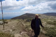
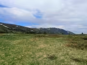
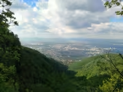
There are two peaks between Kupena and the final ascent to Cherni Vrah – Karachair and Skoparnika. Both can be climbed relatively quickly and easily, as the elevation gain is not significant. They offer interesting views of Sofia and the surrounding mountains and plains. Before the final climb to Cherni Vrah, where we rejoined the trail marked with poles, we took a break and waited for the slower hikers so that we could regroup.
Before reaching Cherni Vrah, the trail passes through an area known as The Three Chimneys. To the right lies Golyam Rezen Peak, home to a radar station with an impressive white dome at its summit. This section was muddy, with water collecting from several snowdrifts that had not yet fully melted. It is here that the first waters of the Struma River originate.
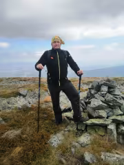
At Cherni Vrah, the cold wind picked up once again, forcing us to seek shelter behind the rocks opposite the summit building. For a Saturday, there were significantly fewer hikers than expected. After everyone in the group had their brief photo session, we gathered together for an improvised lunch, each enjoying whatever food they had brought in their backpack. After the break, we continued downhill in the direction of Konyarnika, Kumata Hut, and Zlatnite Mostove.
The descent is generally uneventful. The main thing is to avoid taking the left turn toward Selimitsa Hut, as there were no signs at the junction. The route to Konyarnika continues straight ahead, or rather slightly to the right. From Konyarnika to Kumata Hut and Zlatnite Mostove, the trail follows the so-called eco-paths. I have no idea whose brilliant idea it was to cover them with fine gravel, but I really do not enjoy walking on that kind of surface. As we approached Zlatnite Mostove, the number of tourists naturally began increasing steadily.

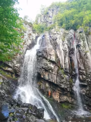
From Zlatnite Mostove, we continued toward Momina Skala Hut and then descended to Boyana Waterfall. In its final section, the trail is very steep and requires extra caution. The waterfall itself is impressive, especially during this season when it is at its fullest. After the obligatory photo session, we followed the red trail markings toward the Boyana district. The path remains very steep and wet, and I would not recommend descending this way. There is an alternative, less steep route marked in green.
We reached Boyana around 7:00 p.m., approximately 10 hours and 20 minutes after starting the hike. While the drivers were being transported back to their cars, the rest of us sat down for a beer at a small kiosk across from Boyansko Hanche.


Add new comment