
The Malyovitsa Lakes are located beneath Malyovitsa Peak, slightly away from the main marked trails, and can be reached only by several steep paths. Ushite Peak rises directly above the lakes, reaching an elevation of 2,547 meters.
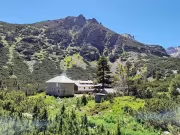
We left Blagoevgrad as a group of eight people in two cars and drove to the former Central Mountaineering School (CPSH). The plan for the day was a more relaxed hike, so we started relatively late. By the time we began walking from CPSH toward Malyovitsa Hut, it was already 11:00 a.m.
The trail to Malyovitsa Hut follows the standard route, and this time it took us about an hour to reach it. We waited on the benches in front of the hut for everyone to gather, refilled our water bottles (which turned out to be unnecessary, as there were plenty of streams higher up), and prepared to continue along the so-called Rabbit Trail.

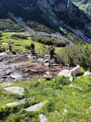
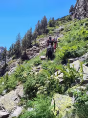
The Rabbit Trail begins just before the hut and immediately starts gaining elevation through dwarf pine. It first winds north, then turns southwest. The route is actually marked with white-red/orange paint and occasional stone cairns. Despite this, I managed to miss the trail at one point and we ended up pushing through dense dwarf pine. It looked like an older path that had once been used but was now heavily overgrown. We retraced our steps and found the proper trail again.

After a steady climb, we reached the start of the via ferrata, where the paths split. If you do not have proper via ferrata equipment, I strongly recommend not attempting it. There had recently been a fatal accident there. We continued along the Rabbit Trail and quickly gained height until we emerged onto Malyovo Pole.

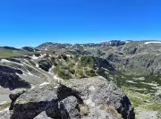
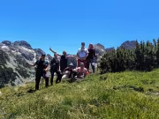
From here, impressive views opened toward Malyovitsa, Orlovets, Lovnitsa, and even the Kupenite peaks in the distance. We gathered for a group photo and continued toward the Malyovitsa Lakes, which were now very close.

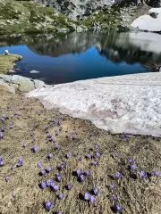
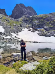
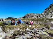
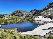
The trail brought us to just a few meters above the first and largest of the three Malyovitsa Lakes. There were still patches of snow around it. The time was 13:45 — about 2 hours and 45 minutes after starting. We paused briefly again and decided to have lunch at the shore of the second lake, which is the smallest of the three, located at 2,355 meters above sea level.

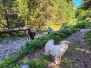
We settled by the lakeshore and unpacked our food. I should mention that Itso had brought his dog Eva along. While we ate, she happily roamed around the lake, occasionally trying to persuade someone to share a bite. After lunch, it was time for a short rest.

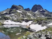
Some of the group stayed to relax near the lake, while the rest of us headed to the upper Malyovitsa Lake, the second largest, at 2,368 meters elevation. After taking a few photos, we continued upward along a path that reaches a ridge above the lake. There is a kind of junction here: one trail climbs the gully toward the saddle between Orleto and Malyovitsa, another heads toward the Urdini Cirque, and a third leads to nearby Ushite Peak.

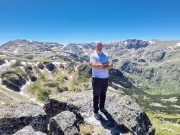
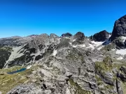
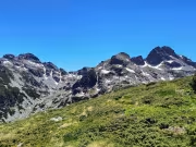
We chose the route to Ushite Peak, which reaches 2,547 meters. From the summit we enjoyed views across the Urdini Cirque, where several of the Urdini Lakes were visible, as well as the peaks towering above them — Zeleni Vrah, Damga (Vazov Peak), Dodov Vrah, the Mermerite ridge, and of course Malyovitsa itself rising dramatically nearby.

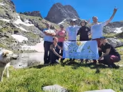
After taking a few summit photos, we headed directly back down toward the second lake, crossing some dwarf pine but without any real difficulty. Once we regrouped, we packed up and continued down to the first lake, this time passing along its shoreline and asking another group of hikers to take a photo of us together.

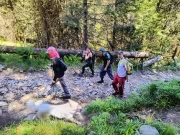
The plan was then to descend via the Ovcharski Gully toward the First Terrace above Malyovitsa Hut. Although we had offline maps, some misleading cairns led us into a neighboring gully. I’m not sure why someone had placed them there — they disappeared at one point, but not before sending us in the wrong direction. After a short detour and spotting another group descending elsewhere, we corrected our course and found the proper path. The upper section of Ovcharski Gully was wet and slippery, requiring extra caution.

From the First Terrace we had a bit more descending to do before reaching the hut, where we took a short break and then continued down to CPSH and our parked cars.
Add new comment